
File:15th Arrondissement of Paris as seen from Pont de Bir-Hakeim 140507 1.jpg

Оригинал файлыр (Пиксел 7,578 × 3,991, файлым иинагъэ: 13.67 MB, MIME-тип: image/jpeg)
КӀэкӀэу
| АгурыбгъэӀон |
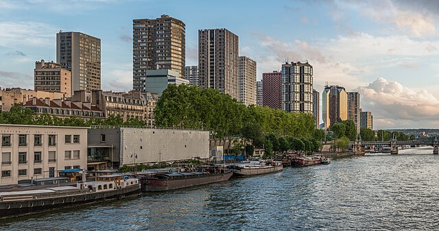
English: The 15th arrondissement of Paris as seen from the Pont de Bir-Hakeim, shortly before sunset.
Español: XV Distrito de París, Francia, visto desde el puente de Bir-Hakeim poco antes del atardecer.
|
||||
| Мафэ | |||||
| КъыздикӀыгъэр | Уилъэжьыгъэ | ||||
| Аутор | DXR |


| Camera location | | View this and other nearby images on: OpenStreetMap |
|---|
Assessment
|
This image was selected as picture of the day on Wikimedia Commons for 7 May 2024. It was captioned as follows: English: The 15th arrondissement of Paris as seen from the Pont de Bir-Hakeim, shortly before sunset Other languages:
Deutsch: Das 15. Pariser Arrondissement gesehen von der Pont de Bir-Hakeim kurz vor Sonnenuntergang. English: The 15th arrondissement of Paris as seen from the Pont de Bir-Hakeim, shortly before sunset Español: XV Distrito de París, Francia, visto desde el puente de Bir-Hakeim poco antes del atardecer. Magyar: Párizs 15. kerülete a Pont de Bir-Hakeimről nézve, röviddel naplemente előtt Nederlands: Het 15e arrondissement van de Franse hoofdstad Parijs, gezien vanaf de Pont de Bir-Hakeim Português: 15.º arrondissement de Paris, França, visto da Ponte de Bir-Hakeim pouco antes do pôr do sol. |
|
|
Panorama by DXR (Category)
The photograph above is a panoramic image which was created by me, Daniel Vorndran, and uploaded here as User:DXR.
Please note:
|


ЛицензиешӀын
- Уфит:
- ягъэшIэн – мы шIагъэм икопие шIын, зэлъагъэшIэн, ыкIи ябгъэхьын
- ремикс шIын – шIагъэр къэштэжьын
- Мыщ тетэу:
- Аттрибуцие (зытхыгъэр къэгъэлъэгъон) – Ауторыр е лицензорыр къэзгъэлъагъорэ зэпыщэр бгъэнэфэн фае (ау къыбдыригъаштэу е пшIэрэм дыригъаштэу къэлъэгъон фаеп).
- фэдэу ягъашI – Мы лэжьыгъэм ышъхьагъ зыгорэ теошIахьмэ, къыкIэкIырэ лэжьыгъэр зэрэзэлъыбдзышъущтыр мы лицензие дэдэм тет къодыеу ары.
Файл тарихъ
Мафэ/уахътэм теӀункӀ итеплъэр ащыгъум зэрэщытыгъэр плъэгъуным пае.
| Мафэ/Уахътэ | рэсым цӀыку | Иинагъэхэр | Нэбгрэ | ПыӀухьажь | |
|---|---|---|---|---|---|
| джырэ | 21:51, 3 Мэкъуогъу 2014 | | 7,578 × 3,991 (13.67 MB) | DXR | Selective cloud brightening top right corner |
| 13:31, 2 Мэкъуогъу 2014 |  | 7,578 × 3,991 (13.67 MB) | DXR | Slight straightening | |
| 13:09, 8 ЖъоныгъуакӀ 2014 |  | 7,595 × 4,000 (14.38 MB) | DXR | Spots removed | |
| 12:59, 8 ЖъоныгъуакӀ 2014 |  | 7,595 × 4,000 (14.3 MB) | DXR | VicuñaUploader 1.20 |
Файлым и гъэфедэн
Мыщ къэзыщэу нэкӀубгъо пари щыӀэп.
Файлым и глобал гъэфедэныгъэ
Мы файлыр мы викихэм агъэфедэ:
- ast.wikipedia.org-м и гъэфедэныгъэ
- av.wikipedia.org-м и гъэфедэныгъэ
- az.wikipedia.org-м и гъэфедэныгъэ
- crh.wikipedia.org-м и гъэфедэныгъэ
- cv.wikipedia.org-м и гъэфедэныгъэ
- de.wikivoyage.org-м и гъэфедэныгъэ
- el.wikipedia.org-м и гъэфедэныгъэ
- en.wikivoyage.org-м и гъэфедэныгъэ
- es.wikipedia.org-м и гъэфедэныгъэ
- fr.wikipedia.org-м и гъэфедэныгъэ
- fr.wikivoyage.org-м и гъэфедэныгъэ
- hu.wikipedia.org-м и гъэфедэныгъэ
- hy.wikipedia.org-м и гъэфедэныгъэ
- id.wikipedia.org-м и гъэфедэныгъэ
- it.wiktionary.org-м и гъэфедэныгъэ
- ka.wikipedia.org-м и гъэфедэныгъэ
- kk.wikipedia.org-м и гъэфедэныгъэ
- ko.wikipedia.org-м и гъэфедэныгъэ
- lez.wikipedia.org-м и гъэфедэныгъэ
- mdf.wikipedia.org-м и гъэфедэныгъэ
- mk.wikipedia.org-м и гъэфедэныгъэ
- myv.wikipedia.org-м и гъэфедэныгъэ
- os.wikipedia.org-м и гъэфедэныгъэ
- pt.wikipedia.org-м и гъэфедэныгъэ
- ro.wikipedia.org-м и гъэфедэныгъэ
- ru.wikipedia.org-м и гъэфедэныгъэ
- sah.wikipedia.org-м и гъэфедэныгъэ
- tt.wikipedia.org-м и гъэфедэныгъэ
- tyv.wikipedia.org-м и гъэфедэныгъэ
- udm.wikipedia.org-м и гъэфедэныгъэ
- uk.wikipedia.org-м и гъэфедэныгъэ
- vep.wikipedia.org-м и гъэфедэныгъэ
- vi.wikipedia.org-м и гъэфедэныгъэ
Мы файлым и глобал гъэфедэныгъэм еплъ.