
File:The Danube Spills into the Black Sea.jpg

Мыщ и ыпэтеплъэм иинагъэр: Пиксел 669 × 600. НэпэмыкI зэхэщыкIэхэр: Пиксел 268 × 240 | Пиксел 535 × 480 | Пиксел 857 × 768 | Пиксел 1,142 × 1,024 | Пиксел 2,080 × 1,865.
Оригинал файлыр (Пиксел 2,080 × 1,865, файлым иинагъэ: 1.07 MB, MIME-тип: image/jpeg)
КӀэкӀэу
| АгурыбгъэӀон |
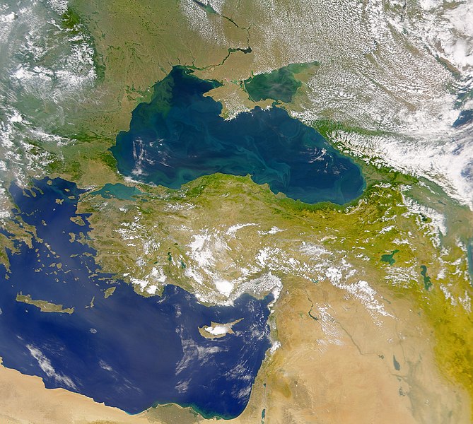
English: This cloud-free Sea-viewing Wide Field-of-view Sensor (SeaWiFS) view of the Black Sea reveals the colourful interplay of currents on the lake’s surface. The green crescent shaped pattern in the north-western corner of the Black Sea is due to the nutrient-rich, sediment-laden discharge of the Danube River stimulating biological activity. The brighter, more turquoise patterns on the lake to the south and east are probably blooms of another type of phytoplankton. |
| Мафэ | |
| КъыздикӀыгъэр | NASA Earth Observatory |
| Аутор | The SeaWiFS Project |
Image courtesy of the NASA/Goddard Space Flight Center, and ORBIMAGE.
ЛицензиешӀын
| This file is in the public domain in the United States because it was solely created by NASA. NASA copyright policy states that "NASA material is not protected by copyright unless noted". (See Template:PD-USGov, NASA copyright policy page or JPL Image Use Policy.) | ||
 |
Warnings:
|
Файл тарихъ
Мафэ/уахътэм теӀункӀ итеплъэр ащыгъум зэрэщытыгъэр плъэгъуным пае.
| Мафэ/Уахътэ | рэсым цӀыку | Иинагъэхэр | Нэбгрэ | ПыӀухьажь | |
|---|---|---|---|---|---|
| джырэ | 11:20, 20 Мэлылъфэгъу 2010 | | 2,080 × 1,865 (1.07 MB) | Originalwana | {{Information |Description={{en|1=This cloud-free Sea-viewing Wide Field-of-view Sensor (SeaWiFS) view of the Black Sea reveals the colourful interplay of currents on the lake’s surface. The green crescent shaped pattern in the north-western cor |
Файлым и гъэфедэн
КIэлъыкIорэ нэкIубгъор ещэ мы файлым:
Файлым и глобал гъэфедэныгъэ
Мы файлыр мы викихэм агъэфедэ:
- crh.wikipedia.org-м и гъэфедэныгъэ
- en.wikipedia.org-м и гъэфедэныгъэ
- eo.wikipedia.org-м и гъэфедэныгъэ
- fr.wikipedia.org-м и гъэфедэныгъэ
- gu.wikipedia.org-м и гъэфедэныгъэ
- hak.wikipedia.org-м и гъэфедэныгъэ
- hr.wikipedia.org-м и гъэфедэныгъэ
- hu.wikipedia.org-м и гъэфедэныгъэ
- ilo.wikipedia.org-м и гъэфедэныгъэ
- ja.wikipedia.org-м и гъэфедэныгъэ
- kn.wikipedia.org-м и гъэфедэныгъэ
- lg.wikipedia.org-м и гъэфедэныгъэ
- pl.wikipedia.org-м и гъэфедэныгъэ
- rm.wikipedia.org-м и гъэфедэныгъэ
- sr.wikipedia.org-м и гъэфедэныгъэ
- ta.wikipedia.org-м и гъэфедэныгъэ
- uk.wikipedia.org-м и гъэфедэныгъэ
- vi.wikipedia.org-м и гъэфедэныгъэ
- wuu.wikipedia.org-м и гъэфедэныгъэ
- zh.wikipedia.org-м и гъэфедэныгъэ